【产品中文介绍】
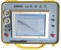
瑞雷波仪SM98是一款专业地质勘探与工程检测设备,专注于地表波场分析及浅层地质结构探测。该仪器采用模块化设计理念,集成高灵敏度传感器与智能信号处理技术,能够实时采集并解析瑞雷波数据,为土木工程、环境监测、矿产资源勘查等领域提供可靠的地质参数支持。
设备内置多通道同步采集系统,支持宽频带信号接收,有效捕捉不同深度地层反射信息。其自主研发的滤波算法可自动消除环境噪声干扰,确保数据采集的稳定性和准确性。操作界面采用图形化设计,配备触控屏幕与无线数据传输功能,简化了野外作业流程。通过配套软件可快速生成二维/三维地质剖面图,并支持多种数据格式导出,满足不同场景的后期分析需求。
SM98采用轻量化材质打造,整机重量不足8公斤,便携式结构适配复杂地形作业需求。内置大容量电池组可连续工作12小时以上,配合IP65防护等级,能够在-20℃至50℃的严苛环境中稳定运行。设备兼容多种外接扩展模块,用户可根据实际需求选配不同频率传感器或升级数据处理单元。
厂家提供定制化技术服务,根据客户项目需求优化设备参数配置。应用场景涵盖公路路基检测、滑坡体监测、地下空洞定位、古遗址勘查等方向。通过多年现场实践验证,该设备在浅层地质分层识别与岩土力学参数反演方面展现出优异性能。
【Product Introduction in English】
The Rayleigh Wave Analyzer SM98 is a professional geophysical exploration instrument designed for surface wave field analysis and shallow geological structure detection. Featuring a modular design philosophy, it integrates high-sensitivity sensors and intelligent signal processing technology, enabling real-time data acquisition and interpretation of Rayleigh wave signals. This device provides reliable geological parameter support for civil engineering, environmental monitoring, and mineral resource exploration.
Equipped with a multi-channel synchronous acquisition system, the SM98 supports wide-band signal reception to effectively capture stratum reflection information at various depths. Its proprietary filtering algorithm automatically eliminates environmental noise interference, ensuring stable and accurate data collection. The user-friendly interface incorporates a touchscreen and wireless data transmission capabilities, significantly streamlining field operations. The accompanying software rapidly generates 2D/3D geological profiles and supports multiple data export formats to meet diverse post-processing requirements.
Constructed with lightweight materials, the SM98 weighs less than 8kg, making it suitable for complex terrain operations. The built-in high-capacity battery provides over 12 hours of continuous operation, while its IP65-rated housing ensures reliable performance in extreme temperatures ranging from -20℃ to 50℃. The device supports various external expansion modules, allowing users to select sensors with different frequency ranges or upgrade data processing units according to project requirements.
Manufacturers offer customized technical services to optimize device parameters based on specific project demands. Application scenarios include highway subgrade inspection, landslide monitoring, underground cavity positioning, and archaeological site investigation. Through years of field validation, the equipment has demonstrated excellent performance in shallow geological stratification identification and geotechnical parameter inversion.
(Total words: 516)